Sunday, August 25, 2013
A favour
For those who have my cell#, please text me the daily forecast for Belleville from Env. Canada. I don't have one of those schmart cellphone thingamagiggers. I'd like to know what ahead of me.
Friday, August 23, 2013
So about next week...
4:30 PM update: latest Env. Can. Belleville forecast has now a 30% PoP and 40%PoP for Monday and Wednesday respectively. They're catching up!
Next week, me and the fam are camping once again at Sandbanks PP, near Belleville, ON. So this morning I check the Env. Can. forecast for Belleville:
Tonight, 23 August: Clear. Low 11.
Saturday, 24 August: Sunny. High 25.
Sunday, 25 August: Sunny. Low 15. High 25.
Monday, 26 August: A mix of sun and cloud. Low 17. High 25.
Tuesday, 27 August: A mix of sun and cloud. Low 17. High 25.
Wednesday, 28 August: Sunny. Low 18. High 25.
Thursday, 29 August: Sunny. Low 16. High 24.
Awesome right?
Not so fast. As you may know, I'm a little skeptical about Env. Can. forecasts. So I checked the output from various models, including the Canadian. The REALLY curious thing is that the above forecast doesn't even agree with the Env Can. model. It shows precipitation in the Belleville area Sunday afternoon/evening and Monday night/early Tuesday..
Next week, me and the fam are camping once again at Sandbanks PP, near Belleville, ON. So this morning I check the Env. Can. forecast for Belleville:
Issued: 11:00 AM EDT Friday 23 August 2013
Today, 23 August: Mainly sunny. High 24. UV index 6 or high.Tonight, 23 August: Clear. Low 11.
Saturday, 24 August: Sunny. High 25.
Sunday, 25 August: Sunny. Low 15. High 25.
Monday, 26 August: A mix of sun and cloud. Low 17. High 25.
Tuesday, 27 August: A mix of sun and cloud. Low 17. High 25.
Wednesday, 28 August: Sunny. Low 18. High 25.
Thursday, 29 August: Sunny. Low 16. High 24.
Awesome right?
Not so fast. As you may know, I'm a little skeptical about Env. Can. forecasts. So I checked the output from various models, including the Canadian. The REALLY curious thing is that the above forecast doesn't even agree with the Env Can. model. It shows precipitation in the Belleville area Sunday afternoon/evening and Monday night/early Tuesday..
 |
| Sunday Evening |
 |
| Tuesday morning |
Most other models are showing precipitation as well, but with significant timing differences at this point, though none are showing any precip in the Belleville area until early Monday morning at the earliest.
Beyond that, the models are all over the place. The Euro has another precip event on Wednesday while the GFS doesn't have much of anything after Tuesday. The issue is that the precipitation is caused by pieces of "energy" circling a ridge in the central portion of the continent. The mid to northern prairies are going to be in a heatwave situation next week and the following. Southern and eastern Ontario will be on the periphery of this ridge and thus the jet stream will be carrying "energy" toward us but the exact path is indeterminate at this point.
The main point is that the rosey scenario painted by Env. Can is wrong...unfortunately. I'm going to have to do some major tarping.
Thursday, August 22, 2013
A milestone...sort of
Tomorrow (Aug 23rd) the sun will set for the first time since April on the area half way between the Arctic circle and the north pole (where the sun will not set until the Fall equinox), at approximately 78N. Consequently, this is the period where Arctic temperatures begin to rapidly drop off.
 And consequently, this is the period where the Arctic sea ice melts begins to decelerate (if it has done so already).


Thursday, August 15, 2013
The next week or so
Looks like next week will be very nice, at least until the Thursday timeframe.
Initially though we'll have to get through tomorrow. A very weak frontal boundary will be passing through which may cause some showers, even thunderstorms tomorrow. But they will be pretty scattered from what I can tell.
From Saturday through Wednesday, it will be mostly sunny and increasingly warm. There is a debate with respect to the timing of the next precipication but it will be in the Wednesday/Thurday timeframe with a stronger cold front coming next weekend...
So if you're on holidays the next few days, bully for you.
Friday, August 9, 2013
The next week or so
Brief post.
Weekend nice, but slightly cooler than normal.
Monday into Tuesday, unsettled with some precip.
Rest of the week nice, but slightly cooler than normal.
Weekend nice, but slightly cooler than normal.
Monday into Tuesday, unsettled with some precip.
Rest of the week nice, but slightly cooler than normal.
Wednesday, August 7, 2013
Tropical Storm season update
As we are heading into the heart of the hurricane season, I thought I'd give an update on this aspect of weather as well. Some were hyping the forecast that this season would be above normal season in the Atlantic. It hasn't played out that way to date. According to the latest stats courtesy of Dr Ryan Maue, all basins of tropical activity are below normal. The Atlantic is @ 65.5% of normal activity with 4 named storms and none yet in August. Now, as I said, we are entering the heart of the hurricane season. We may yet get to above normal in the Atlantic basin. However, I do think the forecast in the links above are over done. But we shall see.
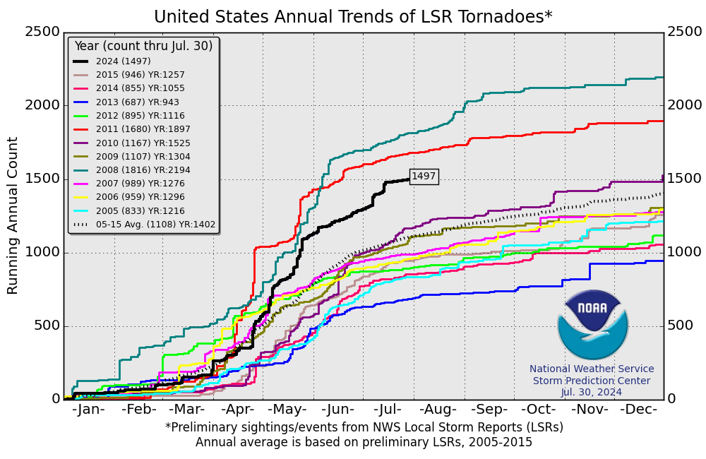
Tornado update
To follow up with my April 18th post.
This year's temperature pattern is significantly different than last year's in North America. Essentially opposite.
 |
| Jan 1 to Aug 5, 2012 Temperature Anomaly |
 |
| Jan 1 to Aug 5th, 2013 Temperature Anomaly |
And yet both years are well below normal in the tornado count. Why? I couldn't tell you, but there's definitely not a corelation with temperatures. This year is close to record low tornado counts.
Tuesday, August 6, 2013
Arctic Ice update
Per my May 29 post, the Arctic ice situation is looking relatively healthy. We have about a month until the melting stops and the re-freezing begins (of the sea water anyway). Based on most datasets we are going to have the highest minimum in quite a few years.
While it may not be cold enough yet to re-freeze sea water, it IS cold enough to snow. The maps below shows the snowfall accumulation in the Arctic over the next week:

Subscribe to:
Posts (Atom)