http://wattsupwiththat.com/2014/08/30/renewable-energy-in-perspective-solar-and-wind-power/
Unfortunately Ontario has similar issues, hence our power bill...
http://www.ieso.ca/Pages/Power-Data/Supply.aspx
Saturday, August 30, 2014
Thursday, August 28, 2014

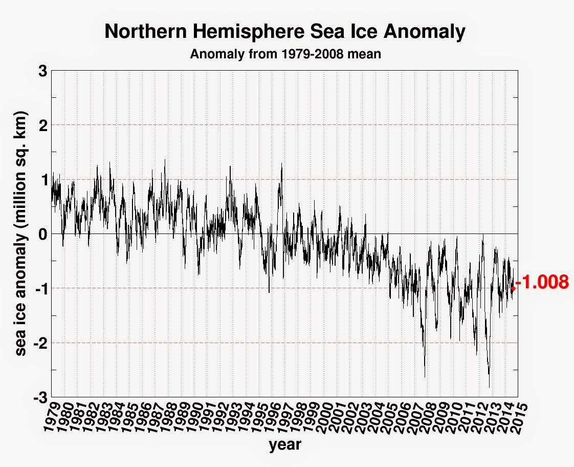
Sea Ice update...
We are a couple weeks from the Arctic sea ice minimum. I thought I'd give an update of where global sea ice is at.
Starting with the Antarctic: still well above normal

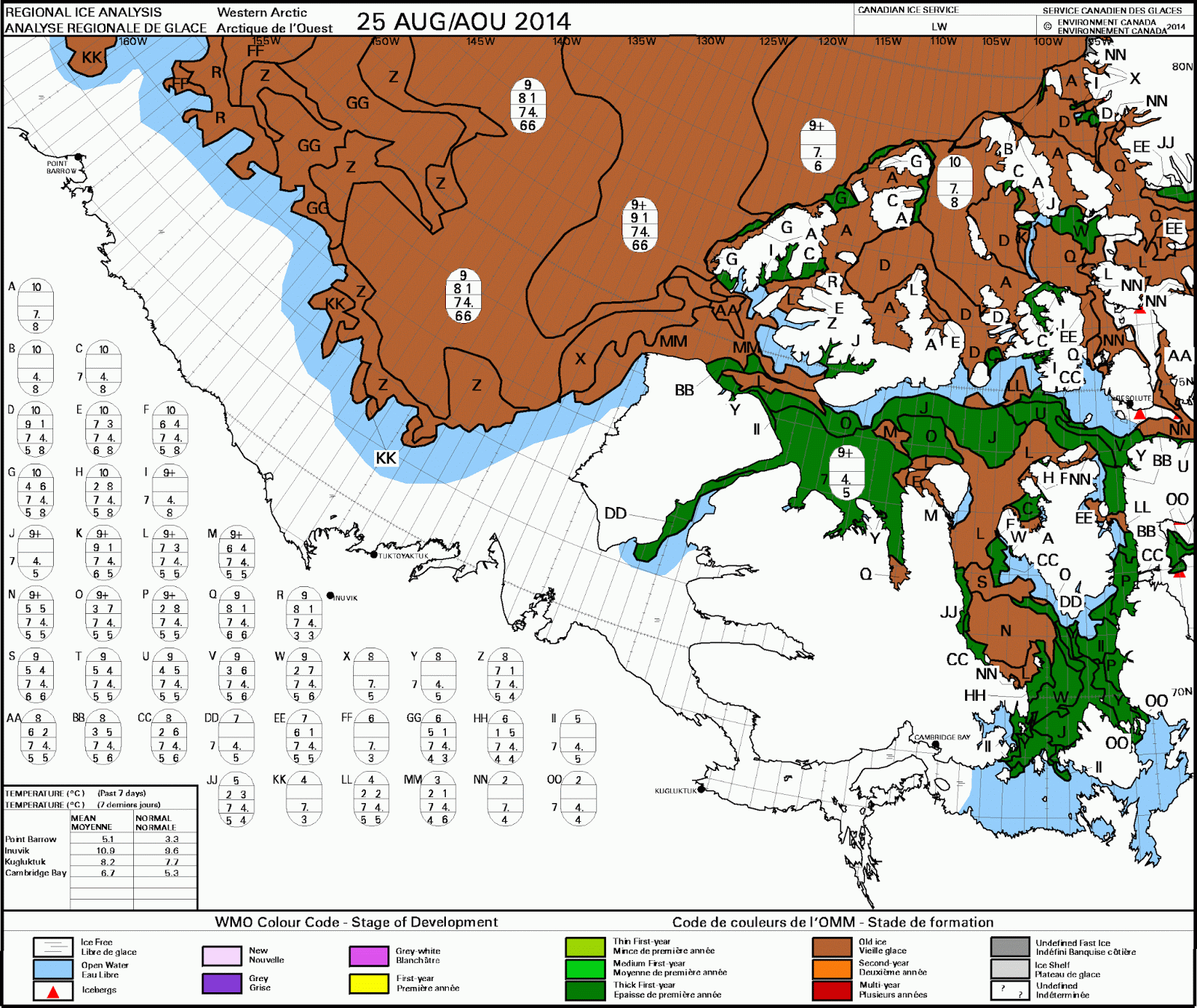
The Arctic Sea ice is approaching this year's minimum. As of now it looks like it'll be pretty close to last years minimum, which was in the middle of the pack of the last dozen. Meaning there is no Arctic Ice death spiral.

If we looks an the anomaly graph, we can also that the ice has stabilized. The extreme minimum of 2012 caused by a strong Arctic storm, has stopped the wild gyrations as we can see in this graph.
The NW passage also won't be open this year as the channels are jammed with old or new thick ice.
Saturday, August 16, 2014
Tuesday, August 12, 2014
Fun fact about August 12th...
Temperature records in Ottawa for this date:
Lowest Temperature (1939-2011) 6.7°C 1946
Highest Temperature (1939-2011) 35.0°C 1947
Lowest Temperature (1939-2011) 6.7°C 1946
Highest Temperature (1939-2011) 35.0°C 1947

Monday, August 11, 2014
How's our summer been so far...
Based on a conversation I had this past weekend, I decided to look into it. For Ottawa (@Ottawa Airport).
June:
Normal Average High Temp: 24.1C
2014 June Average High Temp: 25.2 C
Normal Average Low Temp: 12.9 C
2014 June Average Low Temp: 13.0 C
Normal Mean Temperature: 18.5 C
2014 June Mean Temperature: 19.2 C
Normal Rainfall: 92.8 mm
2014 June Rainfall: 131.0 mm
Conclusion: June was warmer than normal (largely driven by heatwave ending the month) and wetter than normal (driven by a three day event, 11th thru 13th, totalling more than 48 mms).
July
Normal Average High Temp: 26.5C
2014 July Average High Temp: 25.5 C
Normal Average Low Temp: 15.5 C
2014 July Average Low Temp: 13.9 C
Normal Mean Temperature: 21.0 C
2014 July Mean Temperature: 19.7 C
Normal Rainfall: 91.9 mm
2014 July Rainfall: 109.0 mm (with one day with "missing" data)
Conclusion: July was cooler than normal (only two 30+ C days) and wetter than normal (driven by three 20+ mm daily rainfall totals).
August (so far):
Normal Average High Temp: 25.3C
2014 August (to 10th) Average High Temp: 27.4 C
Normal Average Low Temp: 14.3 C
2014 August (to 10th) Average Low Temp: 13.4 C
Normal Mean Temperature: 19.8 C
2014 August (to 10th) Mean Temperature: 20.4 C
Normal Rainfall: 85.5 mm
2014 August (to 10th) Rainfall: 3.6 mm
Conclusion: we are on track to be average in temperature but dry. However, it is interesting to note we have not have a 30+ C day since July 22nd and the odds of getting more are increasing slim as the normals creep down.
Thursday, August 7, 2014
That's what I'm talking about!
(Source: Env Can.)
Monday, August 4, 2014
Quick post on the week
Actually had some time to look at weather stuff...there was a power outage at work.. Anyway...
The rest of the week looks unsettled but mild with spotty opportunities for t-showers.
Starting Friday and into the first part of next week, the weather is looking great. So if you have outdoor plans this weekend, bravo. If not, make some.
The rest of the week looks unsettled but mild with spotty opportunities for t-showers.
Starting Friday and into the first part of next week, the weather is looking great. So if you have outdoor plans this weekend, bravo. If not, make some.
Subscribe to:
Posts (Atom)